Serbia's Topography, Nature & Climate
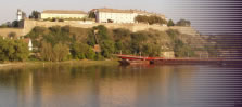
Serbia itself is landlocked - the entire Adriatic Sea coast belongs to rather mountainous and now independent →Montenegro. Geographically spoken, Serbia can be divided into two main parts - the North and the South. Between the two parts, the mighty river Дунав (Dunav, Danube) flows from the west to the east. The Serbian part of the river Danube is 588 km long and therefore Serbia's most important river. In the east, the Danube marks the border to →Romania, in the west the border to →Croatia. The south is characterised by mountains and large plateaus - including the Kosovo. The highest peak is called Ðeravica, has an altitude of 2,656 metres and lies at the border between the →Kosovo and →Macedonia. The area north of the river Danube is mostly flat and characterised by a criss-cross of countless canals. The plain has very fertile soils and therefore it can be called Serbia's granary. Furthermore, smaller quantities of crude oil are exploited in the north. There are only six big cities (big city: defined as a town with more than 100,000 inhabitants) in the country: Among them Ниш (Niš), which is the centre of the southern part, Суботица (Subotica aka Szabadka) in the north, →Нови Сад (Novi Sad) and the dominating capital →Београд (Belgrade, Beograd) (the others are Kragujevać and →Priština, Kosovo).
©2024 Europe-East.com
