Slovakia's Topography, Nature & Climate
Slovakia is a land-locked country dominated by several mountain ranges. Apart from the Danube lowland in the southwest corner around Bratislava, along the Hungarian border, and another small plain at the border triangle →Ukraine - →Hungary - Slovakia, the country is completely covered by more or less high mountains. The Karpaty (Carpathian Mountains) play the biggest role in Slovakia's topography. Rolle.
| ||
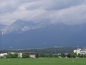
| The High Tatra - as seen from the south near Poprad |
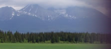
The Carpathian Mountains are divided into several areas - among them a small area at the border to →Poland called the Tatry (Tatra), with the Západné Tatry (Western Tatra) and Vysoké Tatry (High Tatra) as the highest area of the vast Carpathean Mountains. The highest summit there is the 2,655 m high Gerlachovský štit (also: Gerlsdorfer Spitze). The High Tatras are already alpine, but many of the summits can be challenged by amateurs as well - for example the Kriváň (2,494 m), or the Ryzy on the Slovakian-Polish border , which is the highest peak of →Poland with 2,499 m. The main crest of the High Tatras ins only 25 km long. From the town of Poprad south of the Tatras, the mountains look like a huge, massive wall. One characteristic of the Tatras is the large number of so-called "Eyes of the Sea" - small and extremely clear melt water lakes. Even in summer, small snow fields can be found at the northern side of the mountains.
South of the High Tatras runs the small river Váh first westwards before it moves to the south towards the Danube. On the side of the river Váh, when seen from the High Tatras, stretch the larger Nízke Tatry (Low Tatras), which aren't alpine anymore, but the highest mountain there, called Ďumbier, is also more then 2,000 m high. The Low Tatras are characterized by splendid caves and beautiful, pristine gorges. The entire Tatra area is well developed for hiking and winter sports and a popular destination in summer and winter.
Other and smaller mountain ranges in Slovakia are mainly covered by forests and far less frequented then the Tatras. Parts of the mountain areas are protected as national parks. In the very southwest, Slovakia has got it's small share of the river Dunaj (Danube) and in the southeast of the river Tisa (Tisza). Besides those two rivers, the more than 400 km, above mentioned river Váh is the longest Slovak river. The most pristine areas can be found in the northeast, around the Beskids (this part is also often referred to as the Forest Carpathians).
The climate is slightly continental, with cold winters and hot summers. Naturally, the weather around the Tatras is less warm and often unpredictable.
©2024 Europe-East.com
