Montenegro's Topography, Nature & Climate
| ||
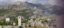
| Lake Shkoder - surrounded by mountains |
Montenegro is a very small country, but the diversity it offers when it comes to nature, it's a fascinating place. As the name "full of mountains" suggests, the country is almost completely covered by mountains - there's not even a coastal plain. Only the area around the capital Podgorica is comparetively flat.
The mountains start right at the coast, with a large part of it consisting of limestone, which means that Karst erosion is a common phenomenon. Coastal mountains reach up to 2,000 metres. In the north and the east, the mountain ranges Durmitor and the rugged Prokletije mountains follow. The highest peak of the country is the 2,536 metres high Zla Kolata in the Durmitor range.
The Orjen mountains near the coast are particularly fascinating - it's the highest mountain range within the Dalmatian mountains and responsible for the Boka Kotorska (Bay of Kotor) (see →Kotor), the largest fjord in southern Europe with sometimes up to 1,300 metre high rock formations starting right at the coast.
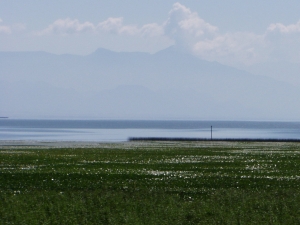
The valley of the river Tara near the Bosnian-Montenegrin border forms a up to 1,300 m deep canyon, making it the deepest valley of Europe. There, one of the four national parks of Montenegro starts - the Biogradska gora (Biograd mountains). The other three are the Durmitor massif, the Skadar Lake (Lake Shkoder, the largest lake in the Balkans, see →Bar: Lake Shkodër and Mount Lovcen.
The climate in Montenegro is clearly mediterranean, with long warm summers and a rather mild winter. At least at the coast. Average temperatures at the coast in summer are around 27 degress Celsius, the water can reach the same temperature. The coast has an average of 180 solar days - most of them in summer - which means there's not much rain in summer. However, the climate gets different in the interior. It's substantially colder and more humid in the mountains. The Zubački kabao in the Orjen mountains can be considered the most humid place in Europe with an average of 6,250 mm precipitation per year. The 1,894 m high peak is covered in snow for around 140 days.
Note that the 260 km long coastline of Montenegro is a tectonically active area - the last devastating earthquake destroyed several towns along the Adriatic Sea in 1979.
©2024 Europe-East.com
