Official Name
Sarajevo. Sometimes also spelled 'Sarajewo'. The name derives from the Turkish words Saray Ova - Saray means "Castle", Ova stands for "Plain". Hence, Sarajevo simply means The plain with the castle.
Location
| ||
| Sarajevo |
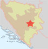
The capital lies in the East of Bosnia-Herzegovina in a rather big basin. In the Western suburbs, the big Bosna river flows from the South to the North. The city itself sprawls along the small Miljacka river from the East to the West. North and South of Sarajevo, up to 1,500 m high mountain ranges form the boundaries of the city. Only 20 km to the East, the small town Pale can be found. There, Bosnian Serbs had established their headquarters during the war. Most of the city belongs to the territory of the FD (Federation). Only a small part of the Southern suburbs belongs to the RS (Republika Srpska).
Population
Compared to other European capitals, Sarajevo is rather small and has around 522,000 inhabitants (1999). The city is ethnically divided - there are almost no Serbs at all living in the centre. By all means Sarajevo is the biggest city of the country.
| ||
| The Twin Towers of Sarajevo |
Orientation
Beware: All data as of 2001! Sarajevo is rapidly changing, i.e. some of the information given might be out-of-date!
The fact that Sarajevo spreads along a river in a long valley surrounded by high mountains was to become the city's undoing during the war. The topographical situation allowed the Bosnian Serbs to besiege and shell the city from all directions. Due to the lack of electrical energy and heating during the cold winters, citizens were forced to cut down the trees all the way to the frontline. That is why the frontline around the town became visible. The old town spreads in the Eastern part of the city, North of the small Miljacka river. There are many bridges across the river - among them the scene of the 1914 incident. Most of the city is North of the river, with the long and wide Zmaja od Bosne road running parallel to the river as the main road. This road is better known as Sniper's Alley.
The train station and bus terminal (of the FD-part!) are adjacent buildings and quite far away from the city centre. But they are close to the main road, and there are frequent trams running from the station along the main road all the way to the old town. The railway tracks end in Sarajevo - all connections are westbound. Most of the olympic facilities can be found North of the train station. War damages are omnipresent, although they are getting less in an incredible speed (see below for more details).
History
Sarajevo is a comparatively young place, probably becoming a town around the 15th century. At that time, the Ottomans ruled the area, which is why the name is of Turkish origin. Eversince, local leaders governed the area from Sarajevo. Sarajevo remained Turkish until 1878, and so it doesn't come as a surprise that the old city has a certain Oriental flair. However, it's less Oriental then →Mostar or →Skopje, capital of Macedonia. After 1878, Sarajevo was ruled by Austria-Hungary and remained not just the capital of the province, but also the centre of resistance. On 28 June 1914, the resistance culiminated in the assassination of the Austrian archduke Franz Ferdinand and his wife by Gavrilo Princip, a Bosnian Serb, in an open car on one of the many bridges. The assassinator had been arrested and brought to the prison inside the fortress of →Terezín (Theresienstadt, Czech Rep.). The successful killing was the final spark needed to set Europe on fire, and so the World War I started (see also →History of Bosnia).
During the Second World War, Sarajevo and the surroundings were a main area for partisan activity again. After the liberation, the city was named as the capital of the newly founded Federal Republic Bosnia-Herzegovina. In Yugoslavian times as well as before, Sarajevo was an ethnic meltpot and microcosm of the Balkans. Muslim Bosniaks, catholic Croats, orthodox Serbs, Jews, Turkish and more lived together more or less harmonically. The year 1984 marked a highlight in the history of Sarajevo - the 14. Olympic Winter Games were held in and around Sarajevo.
After Bosniaks and Croats pleaded for independence in 1992, the tragedy started. In June 1992, Bosnian Serbs backed by JNA (Yugoslavian National Army) forces raised a siege. During the following years, Bosnian Serbs tried to wear down the citizens, cutting off water, electricity and all other supply. Additionally, Bosnian serbs used light and heavy artillery for permanent shellfire. Crossing the main road was life-threatening, since snipers in the surrounding hills tried to pick off everyone daring. The siege lasted 41 months. According to recent estimates, between 16,800 and 20,000 citizens were killed. The one and only connection to the world outside was a long tunnel under the airport, but the route was all but safe. Only by force of arms the UN managed to make the Bosnian Serbs withdraw their heavy artillery and to lift the siege. Since then, thanks to international support, Sarajevo is trying hard to rebuilt the city and repair the damage done.
Getting there / transportation
It's important to know that there are two bus terminals in town. Travellers heading for places within the territory of the Republika Srpska (RS) or →Serbia should go to Lukavica, a southern suburb. Other buses arrive and depart at the above-mentioned central bus terminal. Since Sarajevo is the capital, bus service is frequent. The international airport is not far - it's only 15 km West of the city centre.
There is a daily train to →Budapest (12 h) and regular buses to →Split, →Dubrovnik, →Belgrade, →Zagreb and even to Germany. Numerous buses go to Banja Luka, capital of the Republika Srpska). See also →Travel info on Bosnia for more details.
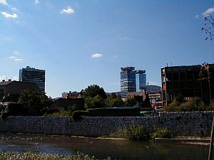
The town has three different faces - all of them more or less marked by the war. One would be the old, Turkish Sarajevo with bazaars and narrow backstreets. This quarter is called Baščaršija. Nearby, the city shows another face - the Habsburg influenced Sarajevo, with beautiful buildings lining up along the Northern riverside of the Miljacka river. Last but not least modern Sarajevo in the West, with the UNIS-Twin Towers as a landmark. Damages caused by the siege are mostly removed in the first two parts.
| ||
| Latinski-bridge: Starting point of WW I |
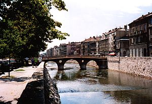
South of the centre, some bridges cross the river. One of them is the famous Latinski-Bridge (formerly known as the Princip-Bridge). On this bridge, the Austrian archduke had been assassinated in 1914, causing many European countries to be sucked into the maelstrom of World War I. The assassinator, Gavrilo Princip, was a Bosnian Serb. And so the bridge was renamed during the siege and a commemorative plaque removed. Princip remains a very controversial person in Bosnian history - adored by Bosnian Serbs, hated by Bosniaks.
Strolling along the Southern riverside is one of the highlights of visiting Sarajevo. The view of the magnificient Habsburg buildings along the Northern side is just beautiful. The hilly old quarter Skenderija opposite the city centre is also worth a visit.
| ||
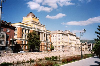
| The Habsburg influenced Sarajevo along the river |
The huge palace-like buildings built during the Habsburg rule include the City Museum, the National Theatre and, at the Eastern edge of the centre, the Austria-Hungarian National Library. When walking along the main road called ul. Mula Mustafa Bašeskija, it's only a few hundred meters to the heart of Sarajevo. There, one will find the Eternal Flame. Parallel to the main road runs the Ferhadija Sarači - a vibrant pedestrian zone and Sarajevo's place to go for shopping and presenting oneself in one of the many street cafés
| ||
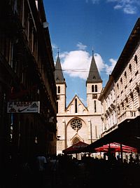
| Roman-catholic Cathedral |
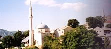
The visitor will soon notice the diversity of Houses of Worship in the centre of town. Which is not limited to churches. Almost every world religion is present - well, I missed a buddhist temple, but even this might be only a question of time. Orthodox and catholic churches, some mosques, an old synagogue - everything is there. To put it in other words - visitors do not have to be afraid of losing their salvation. The twin-towered Rimokatolička Katedrala (roman-catholic cathedral) dominates the modern pedestrian zone and is the eyecatcher of the centre. Walking around this area makes the visitor forget that war had shattered the place only a few years ago.
Within sight of the cathedral some other houses of god concentrate. A small market place called Tržiste is only a few meters away, still in use and quite popular with the locals. As popular as on 5 February 1994, when mortars hit the market during daytime, leaving 68 civilians dead. This could be seen in the news worldwide, but didn't change anything. It was just another tragical story from a far place.
The eternal flame in the heart of Sarajevo is dedicated to the victims of World War II. From there, the main road continues westward and changes its name into ul. Maršala Tito (Marshal Tito Rd.). Eventually, this road leads to the wide Zmaja od Bosne - the backbone of the city connecting the centre with the airport. There is always much traffic on the road, including major bus and tram routes. Not far from the train station, the Historical and the National Museum line up at Zmaja od Bosne. Opposite the museums, the famous Sarajevan Twin-Tower UNIS bldg. can be seen - a landmark, which was heavily damaged during the war. In 2001, reconstruction work was almost comleted, which means that both towers should be completed by now. Next to the UNIS buildings is the bright yellow and brown Holiday Inn, the one and only hotel during the siege catering to journalists and other guests in Sarajevo. Since it was only 300 m away from the frontline in the South, the hotel itself became a target quite frequently. It's renewal had been completed soon after the war to keep business going on.
| ||
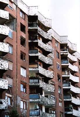
| Residential block in Hrasno |
When following the tram line behind the hotel, it only takes a few minutes to get to the train station and bus terminal. Pass the train station and walk up the street to the north - there you will enter the hilly district Koševo with several olympic facilities. Among the facilities is a large stadium. The olympic games are almost forgotten, but not the siege. Around the stadium, nearly endless graveyards dotted with white wooden crosses sprawl. Even inside the stadium victims were buried, because it was simply too dangerous to bring the dead to other places.
Back to the main road - during the siege it was sometimes the only connection to the outside world thanks to a tunnel under the airport. Due this strategical importance and the fact that it's a wide street and therefore easy to be overlooked, the street and everyone trying to cross it became a target. Hence the name Sniper's Alley. Whoever dared to try to cross it, needed to be fast. The same rule applied to bridges. One of the bridges is called Vrbanja-bridge. There, a memorial tablet can be seen. It's a reminder of a young woman studying medicine, who had been shot dead on the bridge - she was probably the first victim of the war.
Sarajevo was not just besieged - even within the city heavy streetfights broke out. This was mostly limited to the Serbian-hold territory south of the river. Especially the residential areas of Grbavica and Hrasno southwest of the centre became the scene of fierce combat actions. Before the war, mostly Serbs settled around the area. Serbian militia had left scorched earth - even today, wide parts of Grbavica are locked. In Hrasno (see photo) people tried to get back to normal life as quick as possible. In the ground floor of the building in the picture, a very modern Espresso bar had opened. There, the visitor can sip a cappucino while pondering over the war. It's an odd place. I presume, the area looks much better now.
Near Sarajevo, some other places for winter sports, built for the olympic games, can be found. Among them is Pale, 20 km east of Sarajevo. Pale had been chosen as the headquarters of Bosnian Serbs during the war. It is still not recommended to walk around freely outside Sarajevo - the siege has left many minefields and unexploded ordinances (UXO) in the ground. It will take many years to solve the problem completely.
We'd heard about a cheap place called Pansion Train - as the name already says, some old carriages on a siding north of the train station. However, in 2001 it was out of business. Forever !?
There seems to be a lack of cheap accommodation in Sarajevo. There are no hostels and only expensive hotels, so it's not a bad idea to rent a private room. However, even private rooms aren't really a bargain. Among others, Bosnia Tours offers selected private rooms in the centre (which means around the eternal flame). A double is KM 35 per person, breakfast costs an extra KM 10 or so. Opting for private rooms means that it's possible to get in contact with locals - unless the hosts are not interested. We were quite lucky since our hosts were very talkative and even told us many things about the war and its background. Bosna Tours' address: ul. Maršala Tita 54, Tel.: 033-202 207.
- www.sarajevo-tourism.com/eng: English website of Sarajevo's office for tourism. Here, visitors can look for accommodation, departure time and much more.
Do you have or do you know a good website about Sarajevo? Don't hesitate, let me know! After checking it, I would love to add it to the link list. You can submit a link by using the →contact form. Note that commercial websites will be treated differently.
©2024 Europe-East.com
